The profitability of a wind farm depends directly upon reducing uncertainty when wind resources are being assessed and when wind turbines are being fine-tuned. Project risks vary from site to site, depending upon size, site complexity, and whether the wind farm is onshore or offshore. However, there is a tool that can be used to reduce risks. It’s based on light detection and ranging (LiDAR) technology, and it’s becoming indispensable.
Wind turbine power performance characteristics are determined by the measured power curve (the relationship between the wind speed and the wind turbine power output) and the estimated annual energy production. Before siting a farm, it is vital to have an accurate picture of the site’s wind conditions. And once turbines are in place, understanding the velocity and duration of the wind is vital to ensuring its energy is either captured or the turbine is able to adjust to variable wind conditions. Using emerging light detection and ranging (LiDAR) technology enables a producer to see a few seconds into the future, helping evaluate wind parameters, and allowing wind turbine controls and blades to adjust appropriately to the conditions.
LiDAR—a play on the word radar—functions by bouncing a laser light beam off airborne particles that it comes into contact with. The reflected wave is then collected by a telescope, enabling the difference in frequency to be calculated by applying the Doppler effect to the particle speeds. This then determines the wind speed. When combined with advanced data analysis, control algorithms, and the accurate capture of multi-dimensional wind information, LiDAR enables operators to reduce fatigue and peak loads (Figure 1).
 |
|
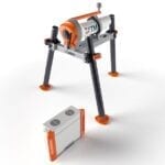
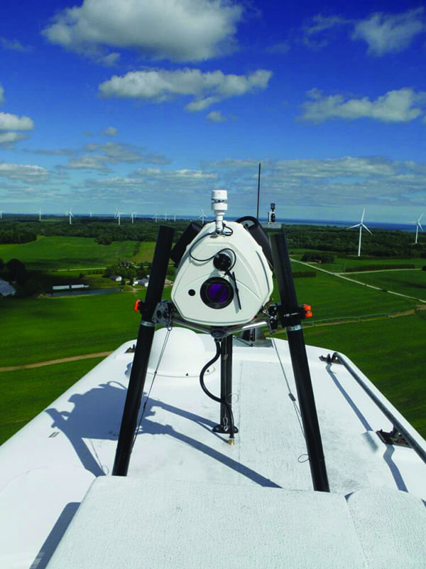
1. More exact wind measurements. Turbine-mounted wind LiDAR systems have been used to measure wind speed and direction, among other things, to validate wind farm performance. New systems are being incorporated into turbine control equipment to optimize real-time operation. Courtesy: ZX Lidars |
A LiDAR measurement can be done as part of the commissioning of a wind farm to compare against the warranted power curve or it can be used as an operational tool to quickly verify wind turbine performance or detect under-performance. When installed during turbine construction, LiDAR-assisted turbine control technology can redefine turbine design limits by mitigating extreme events, increasing energy capture, and reducing loads. For specific projects, turbines can be equipped with larger rotors enabling significant cost-of-energy reductions and lighter towers to reduce wind turbine costs, improving overall power generation and return on investment for the project.
Compared to standard measurement-mast-mounted cup anemometers, data can be collected much faster by a nacelle-based LiDAR system. Additionally, the installation of the nacelle-based LiDAR takes only about a half day and there is no need for a building permit as often is necessary for an onshore measuring mast.
LiDAR Technology Matures with the Wind Energy Sector
One initial finding was that if the rotor blades were turned into or out of the wind soon enough, the rotor speed is kept almost constant, even in the case of gusts. Over the 20 years of a typical turbine’s life, this substantially reduces fatigue as well as extreme loads.
Since then, LiDAR has played an increasingly integral role in wind power development. (see sidebar).
|
Adding to LiDAR’s Repertoire The Offshore Renewable Energy (ORE) Catapult—an ORE technology center in the UK—in collaboration with Centrica, successfully completed an in-field measurement campaign in August 2016 under its blade leading edge program. The testing used LiDAR technology to accurately measure the power performance before and after blade repairs were completed to assess the impact of erosion on performance. The testing found that repairing moderate wind turbine blade erosion could increase annual energy production from 1.5% to 2%. The results give owners a way to balance cost versus benefit when making repair and maintenance decisions. In September this year, ORE Catapult announced that companies looking to test and verify new LiDAR technologies can access its 7-MW Levenmouth Demonstration Turbine in Fife, Scotland. The turbine’s onshore met mast enables the testing, demonstration, and validation of LiDAR systems, providing high-quality wind resources and environmental data that aid developers and manufacturers in comparing and validating new remote sensing techniques against traditional methods. —Aaron Larson is POWER’s executive editor. |
LiDAR’s Impact Demonstrated in the Real World
Windpower Engineering & Development reported that major offshore wind developers at the gathering shared their experiences on a wide range of applications from energy yield assessment and contractual power performance testing to best practices in offshore LiDAR applications and case studies. Based on these testimonies, increasingly LiDAR systems are replacing met masts to become the sole wind measurement tool used for many offshore resource assessments and power curve verification purposes.
 |
|
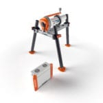
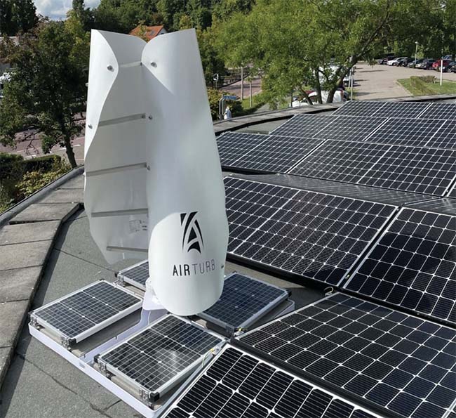
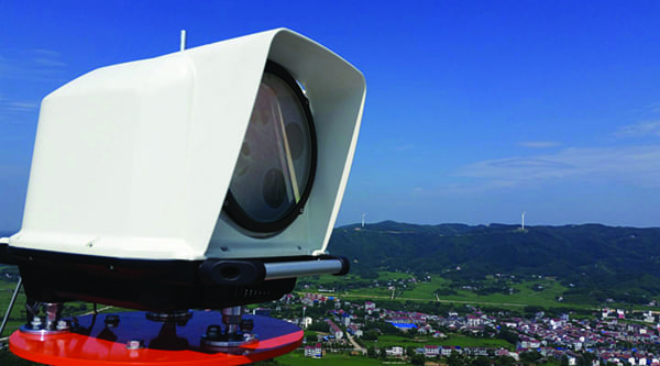
2. Turbine control system optimization. Leosphere claims its Wind Iris TC LiDAR system, shown here, measures all essential incoming wind conditions, including rotor average wind speed, wind direction, shear, and turbulence, at distances of up to 200 meters from the turbine rotor. This enables the turbine control system to achieve the best possible efficiency of wind energy production. Courtesy: Leosphere |
The Beatrice Offshore Wind Farm Ltd. (BOWL) project, a 588-MW, 84-turbine offshore wind farm in the North Sea off Scotland, was one case study featured during the event. The wind measurement campaign for the project was carried out without the use of a met mast. BOWL’s developers chose instead to install two vertical profiler LiDARs that enabled them to start the measurement campaign much earlier and without the significant costs associated with installing an offshore met mast.
The UK’s Carbon Trust, which has opened up vast swaths of the North Sea for resource development, is a firm LiDAR supporter. In trials of floating systems deployed alongside existing offshore met masts to enable the comparison of wind speed and direction measurements, they concluded that savings of up to 90% are possible, based on a typical investment of €10 million for a met mast.
“The Carbon Trust’s floating LiDAR trials have been highly valuable to us at DONG Energy. The framework, established by the Carbon Trust, has enabled the development of floating LiDAR concepts—in terms of technical performance, as well as practical issues of safety and reliability. This work has made significant progress towards a mature and robust technology,” said Richard Khaira-Creswell, senior measurement engineer with DONG Energy.
Prior to these trials, the main barrier to wider deployment of floating LiDAR was a lack of validated data. During the trials, the systems were validated against the Carbon Trust Offshore Wind Accelerator (OWA) roadmap for commercial acceptance of floating LiDAR technology. To further assist developers in effectively deploying floating LiDAR systems, the Carbon Trust also released a 105-page report titled Offshore Wind Accelerator Recommended Practices for Floating LiDAR Systems.
Another major LiDAR supporter is the international energy supplier EDF, which has almost 8,000 MW of wind energy capacity in service, another 1,000 MW under construction, and much more planned. According to the French-based company, as it continued to develop assets in the UK’s North Sea, its UK research and development center created a turnkey protocol based on floating LiDAR “that reduces the high cost of conducting wind-based research offshore…As a result, the cost of offshore wind farm studies is now five times lower.” EDF reports the investment is profitable because of the ease with which floating LiDAR units can be relocated. This in turn makes it possible to conduct more detailed studies on a single site and reuse them for future wind farm projects.
Wind Energy Summit Showcases the Latest LiDAR Technology
“[This order] is the first example of our platform strategy being put into practice,” said the aptly named Thomas Velociter, vice president of Turbine Control with Leosphere. “We’re ramping up for production in even greater volumes,” he added.
Validated in June by DNV GL for use as a component in advanced wind turbines, Leosphere’s Wind Iris TC measures all essential incoming wind conditions, including rotor averaged wind speed, wind direction, shear, and turbulence, before it reaches the turbine rotor and at distances of up to 200 meters. This enables the turbine control system to achieve the best possible efficiency of wind energy production both on and offshore.
Also, in Hamburg, ZX Lidars (formerly ZephIR Lidar) revealed a new turbine-mounted wind LiDAR, the ZX TM. Following a three-year development and testing program, the company says the unit allows turbines to be tuned individually and collectively to actual site conditions, overcoming shortfalls in original site modeling and adapting units to wind conditions that may not have been considered during the design of the wind farm.
With greater than 10 million hours of operation in the field and more than 1,000 deployments, ZX Lidars claims many world firsts, including upwind measurements from a turbine nacelle, turbine wake studies, offshore deployments of both fixed and floating wind LiDAR systems, an industry-accepted validation process, refinancing and repowering of wind farms, successful demonstration of measurement accuracy in a wind tunnel, and total wind project financing from a LiDAR without the need for a met mast. ■
—Lee Buchsbaum (www.lmbphotography.com), a former editor and contributor to Coal Age, Mining, and EnergyBiz, has covered coal and other industrial subjects for nearly 20 years and is a seasoned industrial photographer.