mapping
-
 Technology
Increasing Accuracy on Power Line Surveys
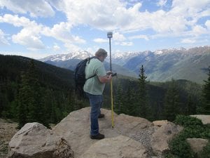
Large-Scale Mapping in Plains of Nebraska Kevin Kenna has lots of experience with GNSS (Global Navigation Satellite System) and major projects for utilities, government agencies, and large-area mapping. He’s used GPS (Global Positioning System) and GNSS for more than two decades and estimates that he has worked on mapping/surveying more than 20,000 miles of power […]